Scroll To Top
Unteres Toggenburg
 
 
Toggenburg panorama Churfirsten Alpenpanorama Bergpanorama Toggenburg chweizer Alpen panorama; Alp Siegel 1769m 35.3km, Hängeten Ostgipfel 2023m 31km, Hängeten 2209m 31.5km, Grenzchopf 2193m 29km, Wildhuser Schafberg 2373m 31.8km. Silberplatten 2158m 28.9km, Gams Chopf 2959m 28.8km, Schafwisspitz 1989m 28.7km, Hinterrugg 2236m 34.1km, Zuestoll 2235m 33.6km. Wart 2068m 32.2km, Schlosshöchi 1033m 4km, Leistchamm 2101m 31.2km. Glattchamm 2097m 31.3km Nägeliberg 2163m 31.9km, Schären 2194m 32km, Frimsel 2267m 32km, Selun2205m 32.4km, Brisi 2279m 33.3km. Schibenstoll 2236m 34.1km, Chäserrugg 2261m 34.9km, Gamsberg 2385m 38.7km. Stockberg 1781m 25.4km, Lütispitz 1987m 28.1km, Stöllen 1967m 28.4km, Schwarzkopf 1949m, 28.9km, Stoss 2111m 29.2km,  Grauchopf 2216m 29.4km, Girenspitz 2248m 29.8km, Grauchopf 2216m 29.4km, Säntis 2502m 30.1km, Hüenerberg 2312m 29.9km, Höch Nideri 2246m 30km, Öhrli  2194m 30.4km, Ebenalp 1640m 33.1km, Wennelichöpf 1616m 38.2km, Kamor 1751m 38.3km
Panorama Lower Toggenburg, viewed from near village Gähwil.
Click on the image to enlarge it to full-screen display in panorama viewer.

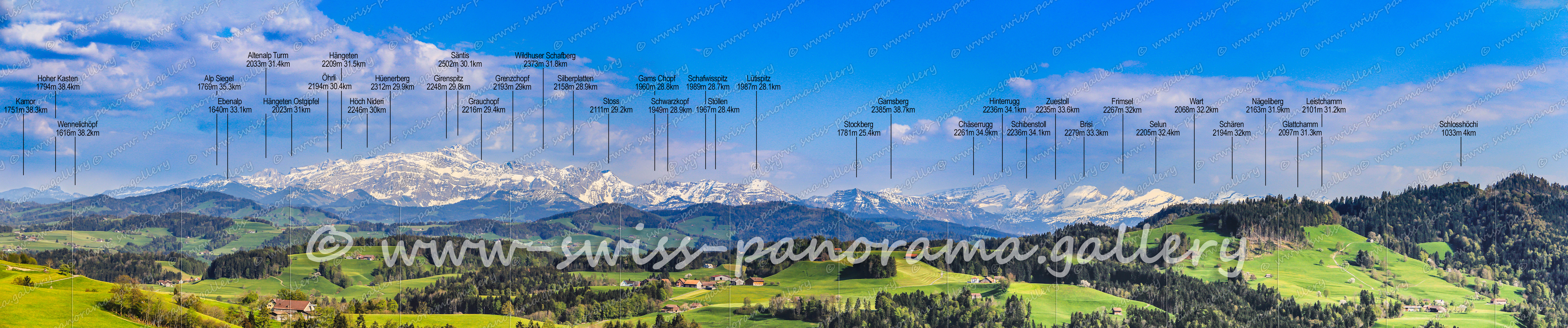
The Lower Toggenburg forms together with the Nekar Valley, the Middle Toggenburg and the Upper Toggenburg the geographic region Toggenburg. The highest mountain is the 2502 meter high Säntis in the Alpstein massif. However, the characteristic landmark of Toggenburg is the mountain range of the Churfirsten.